
The Ghost of Columbus and the Impossible Geometry of the Piri Reis Map
In 1929, while renovating the Topkapi Palace in Istanbul, a theologian discovered a fragment of gazelle skin that would rewrite the history of cartography. This was the Piri Reis map, a world chart compiled in 1513 by the Ottoman admiral and cartographer Piri Reis. While the map is famous for its early depiction of the Americas, a new wave of academic research is peeling back layers of mystery that suggest the map is even more “impossible” than previously thought. Using modern cartometric analysis and digital “mosaicking,” researchers are finding that the underlying geometry of this 16th-century artifact mirrors a level of survey accuracy that defies the technology of the Ottoman era.
The Piri Reis map was not merely a single drawing but a compilation of at least 20 different source maps. Among these, Piri Reis himself claimed to have used eight Ptolemaic maps, four Portuguese charts, and one “lost” map by Christopher Columbus. Because Columbus’s own nautical charts have never been found by modern historians, the Piri Reis fragment is often considered the only surviving “ghost” of Columbus’s original geographic vision. However, the precision of the latitudes and longitudes in the Atlantic sector has led scholars to wonder if the source material was far older than the Age of Discovery.
Mosaics of Accuracy: The Map That Shouldn’t Exist
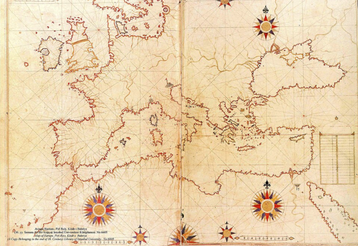
Map from Piri Reis’ Kitab-ı Bahriye showing Europe and the Mediterranean. ( Istanbul University Library / Public Domain)
Recent studies using cartometric analysis, a method of comparing historical maps against modern satellite coordinates, have revealed a shocking discovery. Researchers such as M. Marelić and B. Šlaus have argued that the Portolan charts, which include the Piri Reis map, were constructed as a “mosaic” of smaller, highly accurate regional surveys. These individual “tiles” of the map show a geometric precision that is nearly twice as high as the overall composite. This suggests that Piri Reis was working with source maps that were surveyed with sophisticated instruments, possibly involving early forms of trigonometry that were not widely documented in 1513.
The coastal detail of South America on the Piri Reis map is particularly striking. It depicts the Brazilian coastline with remarkable accuracy, including the mouths of the Amazon and Orinoco rivers. In some sections, the deviation from modern GPS data is less than 50 kilometers (31 miles), a feat that should have been impossible before the invention of the marine chronometer in the 18th century. This has led some fringe theorists to suggest “lost civilizations,” but mainstream academics are now looking toward a more grounded, yet equally fascinating, possibility: an advanced, forgotten tradition of medieval Mediterranean seafaring.
Tracing the Lost Charts of Christopher Columbus
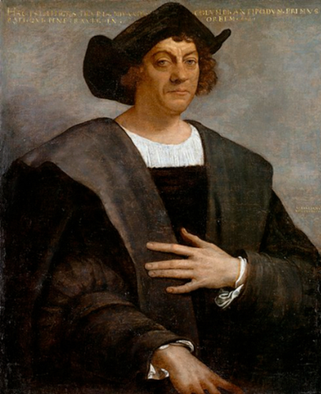
Portrait of a Man, Said to be Christopher Columbus. (Sebastiano del Piombo/Public domain)
One of the most tantalizing aspects of the Piri Reis map is the inscription where the Admiral admits his debt to the “Genoese infidel,” Columbus. According to the text on the parchment, Columbus possessed a book from the time of Alexander the Great that described the lands across the Western Sea. This claim has sent historians on a hunt for the “Columbian source.” If Piri Reis truly copied a map used by Columbus, then the inaccuracies in the Caribbean section of the map, such as the oversized island of Hispaniola, might actually represent Columbus’s own distorted belief that he had found the legendary island of Cipangu (Japan).
The map also features vibrant illustrations of the New World’s fauna. It shows parrots, monkeys, and even mythical creatures like the “Blemmyes,” headless men with faces on their chests. While these seem like mere folklore, they are placed alongside surprisingly accurate descriptions of the climate and local inhabitants. The Piri Reis map thus serves as a bridge between the medieval mindset of monsters and the Renaissance drive for empirical data. It is a snapshot of a world in transition, where the mystical and the mathematical collided on a piece of gazelle skin measuring roughly 60 by 90 centimeters (2.0 by 3.0 ft).
Beyond Piri Reis: The Heart-Shaped Mysteries of the Ottoman Empire
Piri Reis was not the only Ottoman cartographer to produce “impossible” documents. The Hajji Ahmed map of 1559, a cordiform (heart-shaped) world map, also shows a level of geographic knowledge that seems ahead of its time. Most notably, it appears to show a land bridge between Siberia and Alaska, the Bering Strait, long before it was officially “discovered” by Vitus Bering in 1728. When viewed alongside the Piri Reis map, a pattern emerges: the Ottoman Empire was a central clearinghouse for a global “intelligence network” of geographic data that has since been lost to the West.
The “Antarctica” controversy remains the most debated feature of the Piri Reis map. Many have pointed to the bottom edge of the map, claiming it shows the Queen Maud Land coast of Antarctica without ice. Skeptics, however, argue that this is simply the southern extension of South America, curved to fit the dimensions of the gazelle skin. Recent cartometric shifting suggests that if you “unbend” the map’s lower edge, the coastline matches the Patagonian shelf with surprising detail. Whether it represents a frozen continent or a distorted South America, the mathematical intent behind the lines remains a subject of intense academic scrutiny.

Photorealistic reconstruction of the ice-free Antarctic coastline at twilight – evoking the mysterious, ancient landscape that some believe the source maps behind the Piri Reis map may have depicted.
Ancient Archives or Accidental Genius?
As we move deeper into the 21st century, the Piri Reis map continues to challenge our understanding of the past. The “Mosaic Theory” implies that there were ancient archives of geographic data, perhaps dating back to the Great Library of Alexandria, that were preserved by Islamic scholars while Europe was in the Dark Ages. These archives would have contained the collective wisdom of Phoenician, Greek, and Roman mariners who had ventured much further into the Atlantic than history books currently admit.
Ultimately, the Piri Reis map is a testament to the power of synthesis. Piri Reis was a master editor, weaving together threads of Spanish, Portuguese, Greek, and possibly even ancient nautical traditions into a single, cohesive vision of the planet. While we may never find the “lost book” of Alexander or the original charts of Columbus, this Ottoman masterpiece remains a primary witness to a lost era of global exploration. It reminds us that the history of how we mapped our world is not a straight line of progress, but a complex puzzle of discovery, loss, and rediscovery.